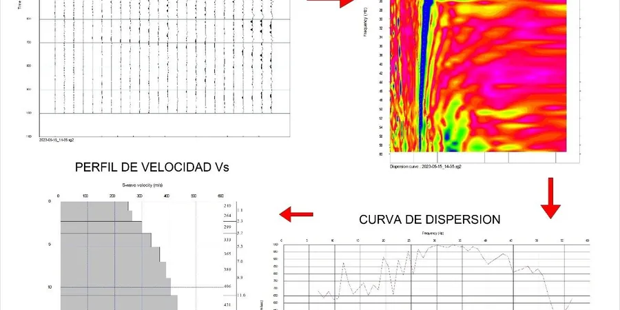
The coastal geology around New Plymouth demands more than a standard borehole log when seismic loads control the design. Volcanic lahar deposits from Mount Taranaki interbed with marine terrace sediments and pockets of softer alluvium, creating sharp lateral velocity contrasts that a single SPT value cannot capture. In our experience across the wider Taranaki region, a MASW array run parallel to the coastline often reveals a 30 % drop in VS30 within 200 metres—critical data when the NZS 1170.5 site subsoil class could shift from C to D. That difference changes the design spectrum, the foundation stiffness, and sometimes the structural system itself. We run active and passive surface‑wave acquisition with 24‑channel seismographs, processing dispersion curves on‑site so the team can flag anomalies before demobilising. The port area, the valley suburbs, and the recent subdivisions on the city fringe each respond differently, and the shear‑wave profile is the variable that ties the geotechnical model to the structural demand. For deeper basin effects we pair the survey with a seismic refraction line, and when the client needs liquefaction screening we add an SPT programme linked to the same velocity grid.
A measured VS30 below 200 m/s in New Plymouth's valley suburbs can push a site from Class C to D, adding up to 40 % to the design base shear under NZS 1170.5.
Methodology and scope
Local considerations
New Plymouth’s urban footprint has pushed steadily onto the ring plain since the 1960s, and many of the subdivisions approved in the 1990s were classified by proxy rather than by direct shear‑wave measurement. The risk crystallises when a site on a gentle slope underlain by lahar breccia sits just above the velocity threshold for Class C, but a single thin lens of saturated pumiceous silt drags the weighted VS30 into the D bracket. That scenario has caught out several projects we have reviewed, where the structural design was locked before the site class was confirmed. Liquefaction susceptibility east of the Waiwhakaiho River is another driver: the NZGS‑MBIE Module 4 guidance ties triggering analysis to shear‑wave velocity, and the simplified SPT‑based method can be conservative in silty sands that the MASW profile shows are stiffer at small strain. Getting the velocity right early avoids over‑engineering the foundation or, worse, under‑estimating the lateral spread demand on piles. Council processing times for building consents in New Plymouth have tightened since the 2022 plan change, and an application backed by a measured VS30 tends to move through the peer‑review stage with fewer requests for further information.
Applicable standards
NZS 1170.5:2004 Structural design actions – Earthquake actions, NZGS Earthquake Geotechnical Practice Guideline (Module 1 & 4), New Plymouth District Plan – Earthworks & Geotechnical Chapter, ASTM D4428 / D7400 (cross‑hole & surface‑wave testing), ISO 17025 – General requirements for laboratory & field testing competence
Associated technical services
VS30 Site Classification Package
One‑day field acquisition with active and passive arrays, inversion modelling, and a signed report assigning the NZS 1170.5 subsoil class. Includes a 2‑D velocity cross‑section, raw dispersion curves, and commentary on lateral variability. Often combined with a shallow auger log to ground‑truth the velocity layering.
Combined Seismic‑CPT Campaign
For projects where liquefaction assessment or deep foundation design is in scope, we run the MASW array alongside a CPT rig. The cone data provides continuous tip resistance and pore‑pressure, while the shear‑wave velocity from both MASW and seismic cone (SCPT) gives a calibrated VS profile that satisfies the NZGS Module 4 requirements.
Typical parameters
Frequently asked questions
How long does a MASW survey take on a typical New Plymouth residential section?
For a standard 600–800 m² lot we usually complete the field work in three to four hours. That includes laying out the 24‑channel spread, running shots in two orthogonal directions, and recording 20–30 minutes of passive microtremor data. If we are pairing it with a CPT or a test pit log on the same day, the full campaign is wrapped up by mid‑afternoon. The inversion and report take another three working days.
What is the cost range for a MASW / VS30 survey in New Plymouth?
For an isolated residential site with a single array and a straightforward site‑class report, the cost typically falls between NZ$2,940 and NZ$4,670 plus GST. The final figure depends on access, the length of the array needed to reach 30 m depth, and whether we are integrating passive methods. A combined MASW‑CPT package on a commercial site will sit at the upper end of that range or slightly above.
Will the council accept a MASW‑derived VS30 instead of down‑hole logging?
Yes, the New Plymouth District Council and their peer reviewers routinely accept surface‑wave methods provided the survey follows the NZGS guideline and the report includes the raw dispersion curves and inversion parameters. We have submitted MASW‑only site‑class reports for dozens of projects in the district, and they have been accepted for building consent without a request for down‑hole seismic.
How does the volcanic geology of Mount Taranaki affect the shear‑wave velocity readings?
The lahar and tephra deposits that blanket much of New Plymouth create a profile that is often stiffer near the surface than the alluvial valleys, but velocity inversions are common—a dense lahar crust over softer pumiceous silt, for example. Our inversion routine handles low‑velocity layers well, but we always flag them in the report because they can control the site period. That layered stiffness is one reason we run both active and passive arrays on every job here.
Do I still need boreholes if I have a MASW survey?
The MASW gives you the small‑strain stiffness profile that drives the site class, but it does not replace the borehole for strength, groundwater monitoring, or soil description. In practice, most projects in New Plymouth use the MASW for the seismic parameters and one or two machine‑dug boreholes or CPTs to build the geotechnical model. The two data sets work together, and we can coordinate the whole campaign so the velocity line and the borehole share the same grid.